oh ... no fuel !
- May 31, 2025
- 5 min read
Well, we did get to Waukaringa following the backroads from Renmark through to Yunta. Once on the dirt we didn't see another vehicle until we hit the road from Yunta to Arkaroola which eventually fringes the east side of the Flinders Ranges.


We drove this section on our last trip ... dirt, washaways, corrugations populated by goats, sheep, cows and wedge tailed eagles...
First night out we free camped off the track at an old salt bore. Very little traffic uses the main road after dark so it was very quiet ... although we were about 1km off the road ... we camped next to a dry salt dam but after a little walk we discovered a a huge waterhole. By this time it was just on twilight and the local kangaroos and emus were coming down to the waterhole and various birds that skimmed the water after insects.


The following day turned out to be a longish day of driving as we eventually went through the top end of the Flinders Ranges, first port of call a visit to Chambers Gorge. Chambers Gorge had been on my radar on the last trip but it was always a bit out of the way. It is about 60kms north east of Blinman and 80kms south of Arkaroola. It is a 9km drive in from the road (bear in mind these are just unsealed, windy second grade roads) with about 6 dry creek crossings weaving under ghost gums and around boulders catching glimpses of the undulating terrain with its layers of red/ocre and yellow/orange. At times you drive along the creek bed ... definately 4WD only ... stunning and definately worthy of another visit and stay.
After this we headed to Blinman where we had morning tea.
Blinman is the highest town in the Flinders Ranges and is 425kms north of Adelaide. It was built on the back of copper that was discovered by a shepherd in 1859. The town is famous for its old copper mine (a tour that we have previously done - well worth it) and the local bakery that serves up quandong pie, traditional cornish pastie and a miners pastie (where one end is apple and the other end is the more traditional meat pastie - an all in one pastie that apparently required no cutlery, the pastry protected the contents from the miners dirty hands. It is said that it could survive being dropped down a mine shaft. Sometimes the maker put the miner's initials in the pastry so there was no confusion as to whose it was).
We then headed along the 4WD route through more winding, narrow, unsealed but spectacular country of the northern Flinders Ranges before emerging on the bitumen at Parachilna (home of the Prairie Hotel - we stayed there last trip - very high end - speciality is its "road kill platter" - check it out).
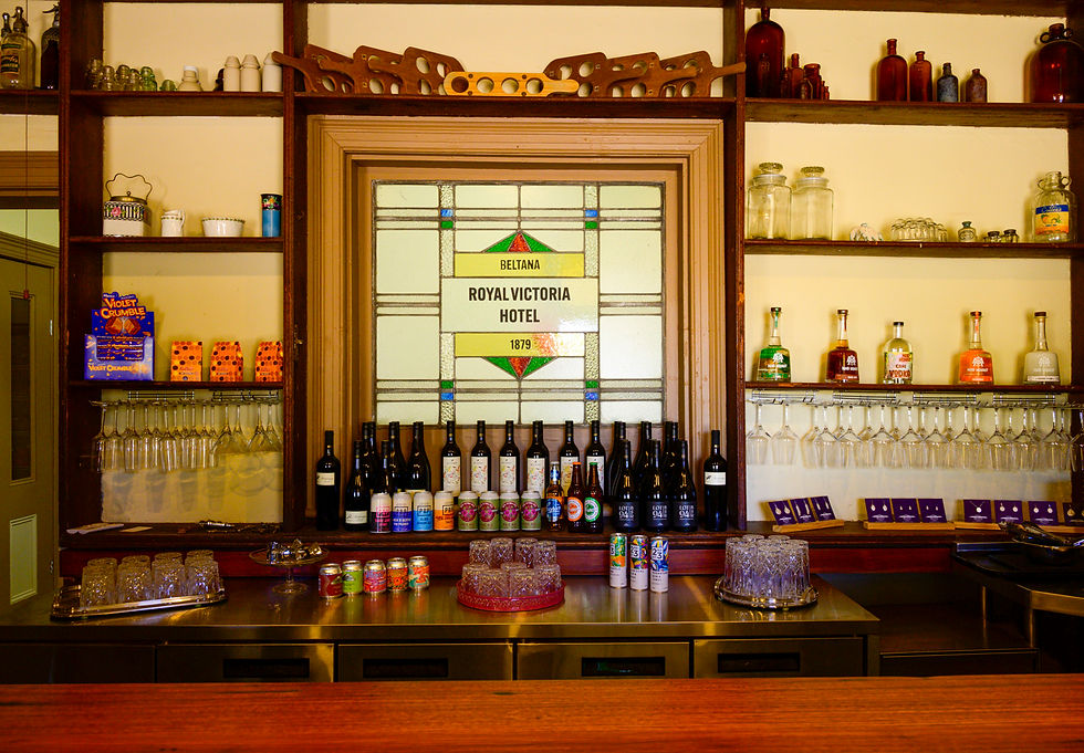
For the night we stopped at Beltana (540kms north of Adelaide) a State Heritage Listed town which is slowly being restored. The town was settled in the late 1850s/60s with many of the original buildings restored. We previously visited here ... you may recall the story of the missing firewood in the town and the 2 bakeries. The culprit was discovered after someone placed some gelignite in their firewood which was subsequently stolen. Kaboom went one of the bakeries ... thief identified ...

The morning of our departure from Beltana they opened the newly renovated/rebuilt Royal Victoria Hotel which last served drinks in 1958 and was built in 1879. Well worth a visit! Just alcohol, open fires and local memorabilia.
Leaving Beltana, we headed up to the start of the Oodnadatta Track stopping at Farina for morning tea. Last trip we visited Farina - not a soul to be seen. This time it is in full swing - volunteers arrive every year around this time to rebuild the original structures and make their speciality - freshly baked bread from the underground bakery. The town has not been inhabited since 1969.
In its heyday, it reached a peak population of about 600 in the late 19th century. It boasted two hotels, an underground bakery, a bank, two breweries, a general store, an Anglican church, five blacksmiths, a school and ... a brothel !!!!
We continued up the Oodnadatta Track to Beresford Siding for the night - a free camp off the side of the track where there are a number of old buildings and structures from when the original Ghan Railway ran through. We camped up behind a disused "fettlers" cottage. It was one of four sites along the line that had giant water softeners built to treat water for the steam locomotives on the Ghan Line. We got chatting to another camper who hailed from Albury. On their maiden voyage in their $165k caravan and Silverado (averaging 30l p/100km) the door had fallen off their fridge and the screws holding the microwave had departed.


After a leisurely start to the day we continued up the Oodnadatta Track and reached the famous pink roadhouse mid afternoon. The track was very rough and corrugated in patches and other patches we could hit 85-90kmph. There wasn't a great deal of traffic ... but if you get stuck behind someone (and some people are travelling at 40-50kph) it can be difficult to get close enough to overtake them due to their dust trail let alone see what is ahead ... usually they can't see you coming or simply don't have, or use their UHF radio.
At Oodnadatta we were greeted by a convoy of about 25 vans all lining the side of the road and were informed that there was no fuel ... there had been a fire in a nearby street (there are only about 2 streets in the town) and there was no power ... it may be back on in about 5-6 hours ... we decided to push on ... thankfully we had the long range tank and still had over 560kms range left.
Before leaving Oodnadatta we enquired about the local road conditions where we were headed ... we had a 2 night booking at Dalhousie Springs which was about 160km up the road. No can do ... road is closed due to flooding ... you can get to Hamilton Station but no further ...
So ... we headed to Marla (255kms) ... more corrugations and broken road ... the first 100kms was magic often reaching speeds up to 100km p/h ... the last 100kms was rough as!!!

We have ended up in a free camp on the Stuart Highway about 80km north of Marla (Agnes Creek Rest Area) ... it doesn't end there ... there has been significant rain in the mid and northern parts of the country ... much of our planned travel routes have now closed ... tomorrow we reassess ...
Today, we passed lots of vehicles on the Stuart Highway covered in orange mud heading south ...
It is hard to reconcile how much rain must've fallen ... we have had 4 days of no wind, clear blue skies, 20 degrees and 5 degrees overnight ... the stars have been impressive ... let's hope they align for us ...


Loving your travels through this great land. Damo & Lea from Demark WA
More beautiful photos 🤗